Planning study news
This wildlife camera monitoring study will inform future improvements to habitat connectivity, which provides safer passage for wildlife across Interstate 5 (I-5) and reduces dangerous wildlife-vehicle collisions. Currently, I-5 is a barrier to wildlife movement and creates unsafe conditions for both humans and animals, hindering movements between the Cascade Mountains to the east and the Willapa Hills and Capitol State Forest to the west. By extension, I-5 restricts wildlife movements between the Cascade Mountains and Olympic Peninsula. Study results will help identify ideal wildlife crossing structure locations to enable wildlife movements between these iconic landscapes.
Purpose
I-5 creates a barrier to wildlife, hampering their east/west movements and leading to the death of many animals that attempt to cross it. Recent studies indicate that I-5, with daily traffic volumes between 38,000 and 68,000 vehicles across both study sites, is a large enough barrier to cause genetic isolation of wildlife populations in Washington (Zeller et al. 2022; Wultsch et al. 2023). This leads to high inbreeding rates and less resilient wildlife populations. A roadway carrying greater than 10,000 vehicles per day is considered a complete or near-complete barrier for most or all species in the area (Charry and Jones 2009).
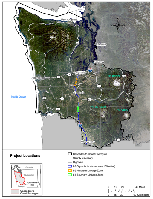
Over a decade of research conducted by the Washington Wildlife Habitat Connectivity Working Group (WHCWG) determined that two linkage zones (A.K.A. “wildlife corridors”), representing approximately 20 miles of linear highway in total, are the last remaining opportunities to provide habitat connectivity across I-5 between Olympia and Vancouver, WA (WHCWG 2022). These two locations, identified by WSDOT as part of the top 15 draft habitat connectivity priorities statewide, are known as the Northern Linkage Zone (NLZ) and the Southern Linkage Zone (SLZ) (Figure 1). Currently, there are no wildlife crossings at these sites.
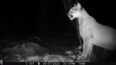
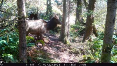
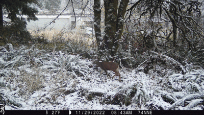
This project involves a high level of collaboration between the WSDOT, Washington Department of Fish and Wildlife, Olympic Cougar Project, Conservation Northwest, U.C. Davis Road Ecology Center, Toutle Lake School, and others. The research is designed to merge efforts where these two wildlife corridors cross I-5 to identify solutions to wildlife-vehicle collisions and the barrier effect that is preventing natural wildlife migration and dispersal. We will use remotely triggered wildlife cameras to document the species and greatest concentrations of animal occurrence in the I-5 right of way to guide optimal wildlife crossing structure site selection in both the NLZ and SLZ, as well as aid future funding proposals.
WSDOT, in collaboration with many others, will produce a wildlife crossing structure feasibility study that identifies ideal locations for wildlife crossing structures based on biological and engineering opportunities (or lack thereof). This feasibility study will include conceptual designs of crossing structures and high-level cost estimates for each. The camera monitoring results from the I-5 Wildlife Habitat Connectivity Study will directly inform the upcoming feasibility study.
Works cited
Charry, B., & Jones, J. (2009). Traffic Volume as a Primary Road Characteristic Impacting Wildlife: A Tool for Land Use and Transportation Planning. UC Davis: Road Ecology Center.
Washington Wildlife Habitat Connectivity Working Group (WHCWG). 2022. Washington Connected Landscapes Project: Cascades to Coast Analysis. Washington Departments of Fish and Wildlife, and Transportation, Olympia, WA.
Wultsch, C., K.A. Zeller, L. S. Welfelt, and R. A. Beausoleil. 2023. Genetic diversity, gene flow, and source-sink dynamics of cougars in the Pacific Northwest. Conservation Genetics.
Zeller, K. A., C. Wultsch, L. S. Welfelt, R. A. Beausoleil, and E. L. Landguth. 2022. Accounting for sex-specific differences in gene flow and functional connectivity for cougars and implications for management. Landscape Ecology, 38(1), 223-237.