Planning study news
We have completed a Planning and Environmental Linkages (PEL) study for the US 2 westbound trestle between Lake Stevens and Everett.
Purpose
The study helps identify transportation issues, environmental concerns, community values and economic goals early in project planning. A detailed environmental review process follows a PEL study, as required by the national and state environmental policy acts. Information gathered in the PEL study is carried forward into the environmental review process, saving time and money.
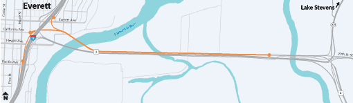
The westbound US 2 trestle in Snohomish County is the only direct highway route across the Snohomish River to the Interstate 5 (I-5) corridor in Everett. Due to significant population growth, the westbound trestle is busier and more congested.
In 2018, we began gathering information about evolving traffic patterns, growth and the effect on the westbound trestle. Our study also made a high-level examination of floodplains, wetlands and fish-bearing streams.
A panel of traffic engineers, transit experts, land use planners and elected representatives studied different replacement and improvement options. The study also included initial community engagement with residents and trestle users.
Concepts analyzed
The study started with several dozen concepts. Most were immediately eliminated due to safety concerns or the high cost of rebuilding portions of I-5 to accommodate new or improved US 2 connections. Two emerged as the most practical and were selected for additional evaluation:
- Concept 2: A four-lane trestle with three general purpose lanes and one high occupancy vehicle lane.
- Concept 3: A three-lane trestle with three general purpose lanes, one of which becomes a short HOV/bus bypass lane just prior to the I-5 interchange.
Prior to developing and evaluating these two concepts, project and traffic engineers forecasted the amount of traffic expected on westbound US 2 in year 2040. The forecast used projected population, business growth and transit plans. This includes Community Transit's long-term plans and Sound Transit's planned light rail extension to Everett.
Environmental considerations
The area surrounding the existing trestle presented many challenges. The structure crosses fish-bearing streams, floodplains and wetlands. There may also be cultural resources that will require consultation with local Native American tribes and other agencies. Additional information about environmental considerations is available in the appendices.
Fish bearing streams
Many species of fish including Chinook salmon, chum salmon, coho salmon, pink salmon, bull trout, cutthroat trout and steelhead trout are found throughout the study area between the Snohomish River and SR 204.
Floodplains
Ebey Island is directly under the trestle. The entire island is considered a floodplain. Some areas of the island are considered a floodway. A floodway is the channel of a river or stream and the land next to it that must remain free from obstruction so that a 100-year flood can be carried downstream.
Wetlands
Dozens of wetlands that surround the US 2 trestle must be protected from highway storm runoff during construction. They consisted mostly of swampy or marshy areas with rooted plants and grasses such as cattails, reeds and ferns. Other areas are dominated by woody vegetation from ground level to more than 20 feet tall. The plants found in these areas include willows, alder, white pine, mature red maple and elm trees. There is also an established WSDOT mitigation site near Home Acres Road.
Community engagement
To ensure we heard from community members, we conducted an online open house from Monday, September 14 – Friday, October 16, 2020 to share our findings. An accompanying online survey asked people who use the westbound US 2 trestle and area residents about their experiences on it.
More than 2,200 people took the survey. We asked 17 questions not including demographic questions. The study questions and results are available in the appendices.
Survey highlights
Top three problems with the existing trestle
- More than 58% believe the problem is not enough lanes.
- 53% said population growth has overwhelmed the trestle.
- 45% said the existing ramp to southbound I-5 can't accommodate peak period traffic.
Use of transit, carpooling/vanpooling
- More than 55% said they will not use transit.
- 29% said direct transit service with no or fewer transfers would encourage them to use it or use it more often.
- 26% said a dedicated HOV lane would encourage them to try carpooling or vanpooling.
Paying for a new bridge or improvements
- 41% supported using the existing gas tax.
- 28% did not support using the existing gas tax, user tolls, a Snohomish County tax or a combination.
- 21% chose "other" and added comments stating opposition to tolls or any additional taxes.
Due to the COVID-19 pandemic, we did not hold in-person events or meetings during the community engagement period. We plan to do more community outreach, particularly with limited English-proficiency residents and other under-represented populations, if future phases of the project development receive funding.