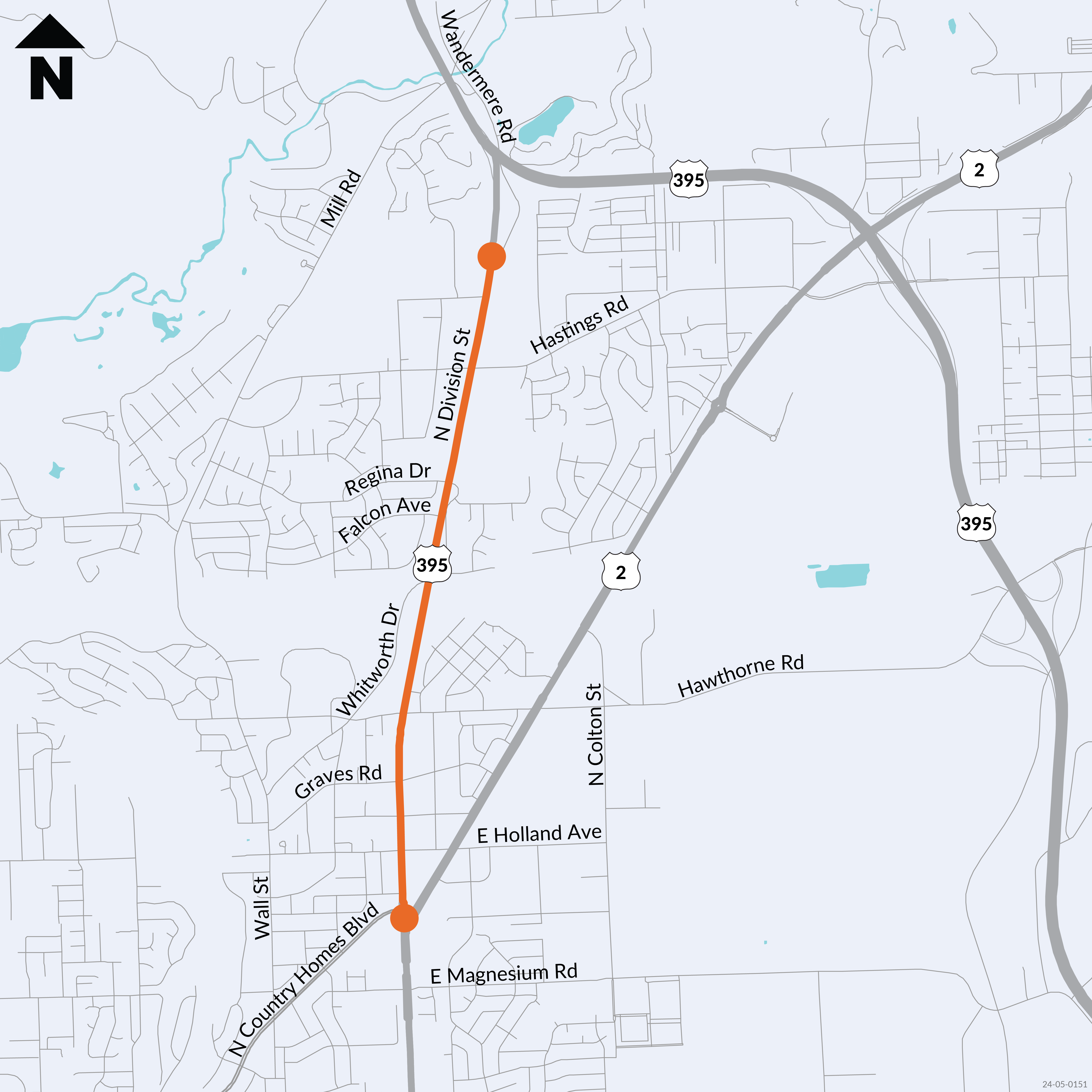
US 395 – Division Wye to Wandermere – Paving – Complete Streets
Project
US 395 – Division Wye to Wandermere – Paving – Complete Streets
Project overview
US 395 from the US 2 Wye to Wandermere Road – milepost 164.5 to 167.07 – has been identified as needing the asphalt concrete pavement rehabilitated to preserve the roadway structure and the public investment in highways. The Complete Streets screening process found this project required implementation of the Complete Streets requirement for the full length of the project corridor.
This project is currently in the pre-design phase to identify, select, and begin the design of the necessary Complete Streets strategies to implement as part of a paving project for this corridor. The addition of Complete Streets strategies to the paving project aims to improve the active transportation environment along and across the project corridor.
Pre-design is expected to be completed in the spring of 2025, with full design staring in July of 2025. This project will be delivered using the Design-Bid-Build process, with construction anticipated to begin in the summer of 2026. This schedule is preliminary and may change depending on the results of the pre-design phase.
Upcoming Engagement Opportunities
The project team has developed strategies to improve walking, bicycling, and rolling for along and across the project corridor based on an analysis of existing conditions, community input, and WSDOT standards. WSDOT held an open house to showcase the strategies on April 2, 2025, both in-person and virtually. Project design information and strategies can be found on the Maps & drawings tab, which was updated for the open house.
For more details on Complete Streets and other general questions, please refer to the FAQs under the Related Links tab. A general online comment card also remains available to provide input to the project team at any time for the remainder of the project.
US 395 from the US 2 wye to Wandermere Road – milepost 164.5 to 167.07 – has been identified as needing the asphalt concrete pavement rehabilitated to preserve the roadway structure and the public investment in highways. The original scope of this project involved rehabilitating the existing pavement with a hot mix asphalt pavement and upgrade basic safety features within the project limits to maintain safe highway operations.
In 2022, Move Ahead Washington was passed by the Washington State Legislature, which included a requirement for WSDOT to incorporate principles of Complete Streets into transportation projects with an estimated budget greater than $500,000 and starting design on or after July 1, 2022. To aid in the implementation of this requirement, WSDOT established a Complete Streets process that first screens all programmed projects for Complete Streets applicability, and subsequently provides a planning and conceptual design phase – known as pre-design – and target outcomes for projects that are required to incorporate Complete Streets. More information about the Complete Streets requirement and WSDOT’s implementation process is available on WSDOT’s Complete Streets page.
The Complete Streets screening process found the US 395/Division US 2 Wye to Wandermere Road paving project to require implementation of the Complete Streets requirement north of Country Homes Boulevard, as no pavement rehabilitation is being done between the US 2 wye and Country Homes Boulevard. A pre-design phase was initiated to conduct this analysis and identify the preferred Complete Streets implementation along and across the corridor. The pre-design phase includes the following tasks:
Coordination with local and regional jurisdictions.
Identification of Complete Streets gaps and needs.
Community engagement.
Development and selection of preferred Complete Streets alternatives.
30% design of preferred alternatives.
Documentation
Community engagement summary and results to date
A series of engagement activities were conducted surrounding a Community Workshop on Tuesday, June 11, 2024, at Whitworth University. Prior to the workshop, project details and an invitation to the Workshop were shared at the Fairwood Farmers Market on Tuesday, May 28 and flyers distributed to businesses along US 395/Division Street on Thursday, May 30. Additional engagement included a second visit to the Farmers Market and two listening posts: one at Rosauers Supermarket, focused on inviting the community to the Workshop, and another at the Rockwood at Whitworth Retirement Community, which gathered feedback on key destinations and crossing concerns.
The Tuesday, June 11, Workshop, attended by 15 participants both in-person and online, featured interactive mapping exercises and survey questions to gather input on the community’s active transportation patterns and needs. Two online surveys designed to gather similar input as the workshop were distributed—one for Whitworth staff and students (available from May 9 to June 24) and one for the broader community (open from May 29 to June 24)—received nearly 100 responses combined. The community-wide survey, promoted through various channels such as social media and the Mead School District, included a link to an interactive online map tool for location-based feedback, allowing further input from those unable to attend the workshop.
Participant demographic data
Through a variety of outreach efforts—including a hybrid workshop, listening posts, and online surveys—the WSDOT project team engaged with the community. Approximately 15 individuals participated in the hybrid workshop, while nearly 100 people completed the online survey. Below is a summary of the demographic data collected from participants.
Walking & bicycling use and challenges
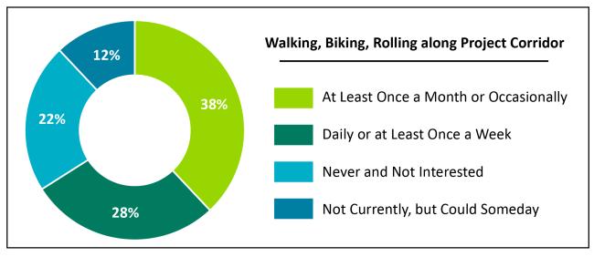
Workshop attendees and survey respondents shared how often they walk, roll, and/or bike along the project corridor. As shown in the pie chart below, 28% reported using the corridor daily or at least once a week, while 38% use it at least once a month or occasionally. 12% mentioned they don't currently use it but could someday, and only 22% indicated they never use it for biking, walking, or rolling and have no interest in doing so.
Pie chart showing how often people bike, walk or roll along the US 395 corridor between the Division Wye and Wanderemere in Spokane
When walking, bicycling, or rolling the corridor, 48% of respondents do so to visit businesses or services, while 40% say they commute to work or school. 34% do so for recreation, while 7% access the bus. With Spokane Transit planning for bus rapid transit on the corridor, those accessing the bus is expected to increase, as there is limited bus service around the corridor today.
The most significant challenges when crossing US 395/Division St. are high vehicle speeds and the lack of physical barriers separating them from traffic. Other concerns include the perception of not being seen by drivers and insufficient space between them and vehicles. Additionally, many find there is not enough time to cross.
When asked where people currently cross US 395/Division St., nearly every cross-street was identified, including those where crossings are currently prohibited. Similarly, when asked where would people like to cross but don’t currently, nearly every cross-street was identified, as was a mid-block location between Hastings Rd. and Farwell Rd. These results show that there is a need for more legal crossings, and that existing signalized crossings do not provide enough features to make everyone feel comfortable crossing.
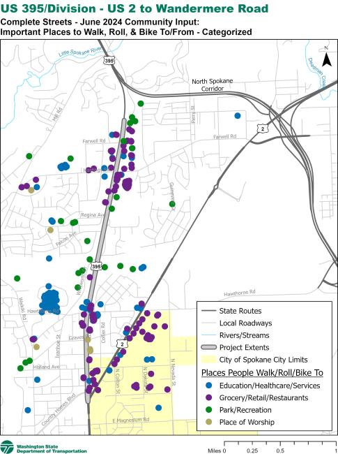
Walking & bicycling destinations
Workshop attendees and survey respondents were asked to identify where they currently or would like to walk, bike, and roll to in proximity to the project corridor. Results of this activity are provided in the following map. There are destinations surrounding the entire corridor on both sides; however, clustering of destinations exists between Regina Ave. and Farwell Rd., between US 2 and Hawthorne Rd. and including the Whitworth University area, and along the US 2 corridor up to Hawthorne Rd. This exercise helped the project team understand that bicycle and pedestrian access is needed on both sides of the project corridor and along its entirety.
Separated bicycle lane comfort
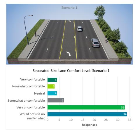
To meet the legislative Complete Streets requirement and WSDOT’s Complete Streets process, it was known up front that bicycles would have to be provided separation from motor vehicles, but the ability to offer a shared use path would have significant challenges. Workshop attendees and survey respondents were shown three scenarios of a location like that of somewhere on US 395/Division St. near Hawthorne Rd. and asked how comfortable they would be bicycling in the shown environment, including different types of separated bike lanes. The first scenario showed the existing layout of Division St., while Scenario #2 showed this location with a bike lane separated using tubular markers and Scenario #3 showed this location with a bike lane separated using a concrete curb.
Comfort level of respondents for proposed scenario 1, separated bike lanes on US 395 from the Division Wye to Wandermere.
Comfort level of respondents for proposed scenario 2, separated bike lanes on US 395 from the Division Wye to Wandermere.
Comfort level of respondents for proposed scenario 3, separated bike lanes on US 395 from the Division Wye to Wandermere.
The purpose of this activity was to understand how the community viewed softer separation (tubular markers) compared to more robust separation (curbed). Based on the survey scenarios, tubular markers significantly improve comfort levels compared to the existing environment, but participants expressed a preference for more physical separation. Respondents found the existing conditions to be very uncomfortable. While tubular markers help increase perceived comfort, the image featuring concrete curbs as a barrier resulted in a much higher level of comfort.
Potential speed reduction along corridor
Speed limit reduction pie chart showing that over 50% of those surveyed would use a separated bike lane if the speed on the US 395 corridor was reduced.
More than half of the respondents agreed that reducing speeds would make biking on a separated bike lane more comfortable. They feel that the current speed of traffic is high or that drivers are not sufficiently aware of their presence. One respondent indicated that street design, rather than signs, is more effective for safety, and two noted that more driver reaction time is needed. Several individuals emphasize the need for stronger barriers in all scenarios, suggesting that physical separation, like adding trees between bike lanes, would be more effective. Others worry about cars turning across bike lanes and stress that walkability and ease of judging car speeds are important considerations.
When asked where along the corridor they would support a speed reduction, nearly half of respondents supported a reduction for US 2 to Hawthorne Rd. Support decreased as you move north towards Farwell Rd., but about a third of respondents still supported a speed reduction up to the northern limits of the project. About one third of respondents noted they would not support a speed reduction on the corridor.
Complete streets gaps analysis
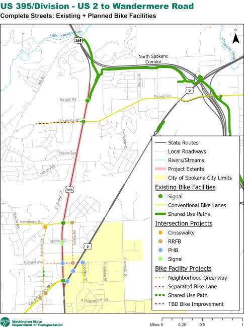
Analysis of collected traffic counts, posted speed limits and observed travel speeds, number of lanes, and existing bicycle and pedestrian facilities was used to calculate the Level of Traffic Stress (LTS) rating for bicycles and pedestrians – a measurement of how comfortable a roadway is to bicyclists and pedestrians, where LTS 1 is comfortable to everyone and LTS 4 is only comfortable to a very small portion of the population. WSDOT’s standards require Complete Streets projects to achieve LTS of 1 or 2 for both bicycles and pedestrians. From Country Homes Boulevard to Farwell Road, the pedestrian LTS is almost entirely 3 or 4 (even for existing sidewalks) and for bicycles is entirely LTS 4, meaning a gap exists for both bicycles and pedestrians (the existing Children of the Sun Trail north of Farwell Road achieves LTS 2). The maps below show the bicycle and pedestrian LTS ratings for the project corridor.
WSDOT currently does not have a similar way to assign a LTS rating to bicycle and pedestrian crossings. The project team must identify potential crossing improvements and locations to implement based on what improvements are selected for along the corridor, existing and planned bicycle and pedestrian infrastructure on cross streets, current and future land uses, needs identified by the community, and trying to enable the most direct route possible by reducing out-of-direction travel. The map below shows existing and planned bicycle and pedestrian infrastructure along and around the project corridor, including where crossings are currently prohibited or limited.
Existing bicycle level of traffic stress
The associated map shows that the US 395 Division Street corridor is considered to be a high stress area for those wanting to bike along the route.
Existing pedestrian level of traffic stress
The associated map shows that the US 395 Division Street corridor is considered to be a high stress area for pedestrians along the route.
Existing and planned facilities along the corridor
The associated map shows that the US 395 Division Street corridor proposed bike facilities that include rapid flashing beacons and other various updates the route.
Spring 2023 - Summer 2027
Milestone
March 2023
Pre-design phase initiated.
May 9, 2024
Whitworth University Students and Staff online survey went live
May 28, 2024
Fairwood Farmers Market Booth
May 29, 2024
Community wide online survey is live
May 30, 2024
Distributed fliers to businesses advertising community workshop
June 4, 2024
Listening Post at Rosauers Supermarket
June 6, 2024
Listening post held at Rockwood Retirement at Whitworth
June 11, 2024
Community Workshop was held at Whitworth University to introduce the project and get their needs and preferences for active transportation.
June 18, 2024
Fairwood Farmer Market Booth
June 24, 2024
Online survey closed
October 31, 2024
Results of the Community Workshop, Complete Streets gaps analysis results, and initial proposed bicycle and pedestrian improvements posted.
Automated financial tables are not available at this time
This tab contains information about the strategies selected and under consideration to improve walking, rolling, and bicycling infrastructure along and across the project corridor as shown at the April 2, 2025, Complete Streets Open House. You can also download copies of the boards presented at the open house.
As noted on the History & Background tab, this project is required to address gaps in bicycle and pedestrian infrastructure between Country Homes Boulevard and Farwell Road to achieve a Level of Traffic Stress (LTS) of 1 or 2 (to learn more about LTS, please see WSDOT’s Level of Traffic Stress flyer). It must also improve crossings, including connections to infrastructure on cross streets. This tab goes into detail about the design strategies that have been selected and those still under consideration for along and across the project corridor. This includes what considerations that went into developing the strategies, why selected strategies were chosen, and visual examples of what the final design could look like. They are split between the following sections:
Corridor-Based Strategies
Crossing-Based Strategies
Other Strategies
This information will be presented at the April 2, 2025 Complete Streets Open House. Feedback specific to these strategies can be provided via survey question links embedded in the text throughout this tab.
Corridor-Based Strategies
This section reviews proposed bicycle and pedestrian improvements for along the US 395/Division Street project corridor.
Corridor-Wide
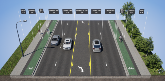
Bicycles and pedestrians must be separated from the motor vehicle traffic in order to achieve LTS 1 or 2 on this corridor due to the number of traffic lanes, traffic speeds, and traffic volumes. Separation can be accomplished in many ways including shared use paths or a combination of separated bike lanes and sidewalks. Because right-of-way space is limited and there are numerous driveways along the project corridor, separated bike lanes with adjacent sidewalks was selected as the baseline (minimum standard) to achieve Complete Streets along the project corridor.
Separated bike lanes, also known as protected bike lanes, are physically divided from motor vehicle traffic by barriers. For this project, the team recommends sidewalk-level separated bike lanes in both directions rather than other forms of separated bike lanes. This places the bike lane at the same elevation as the sidewalk but is physically separated from both pedestrians and vehicles. A concrete curb will be used to separate the roadway from the bike lane while a buffer, such as patterned concrete, will separate the sidewalk from the bike lane, providing cyclists with a dedicated and more comfortable space. This design enhances comfort by distancing cyclists from traffic and reducing conflicts with pedestrians, while also being easier and less costly to maintain over time.
The image below provides a general example of the cross-section the project has selected for along the project corridor.
Image
Image of the typical cross-section of what US 395/Division Street could look like with protected bike lanes and sidewalks.
This consists of the following for both directions of US 395/Division Street:
Adding 6-foot sidewalks where sidewalks are missing, in poor condition, or substandard and keeping existing sidewalks that are at least 5 feet wide and in good condition.
Adding a 5-foot separated bike lane at sidewalk level, between the back of curb and sidewalk, with an additional 2-foot buffer between the bike lane and sidewalk. Keeping all general purpose through lanes (2 in each direction, with the existing third northbound lane starting at the southern Fred Meyer entrance being kept as well), but narrowing to 11 feet.
A 2-foot curb and gutter with a potential white stripe. This will not be part of the 11 feet of the adjacent travel lane and will be treated as a buffer between the travel lane and separated bike lane at sidewalk level.
Keeping the center left turn lane, but narrowing it to 10.5 to 12 feet. Exceptions include leading up to and across the bridge over Whitworth Drive, where a center lane is not needed, and possibly in front of Fred Meyer (see question below about this section).
Based on feedback from the community in the fall of 2024, the design team is looking at ways to enhance the space between the separated bike lane at sidewalk level and the travel lane. Challenges such as available right-of-way and drainage limit the ability to add more space, but the following strategies are being investigated:
Reducing the 2-foot buffer between the sidewalk and bike lane to a 1-foot buffer and adding a 1-foot buffer between the bike lane and back of curb.
Using a rolled curb rather than a flat curb, which is wider and occupies more of the 2-foot “curb and gutter” space, effectively enhances another 1-foot of the gutter to be more of a buffer. The rolled curb is the same height as a regular curb and also allows for a bicycle that goes past the curb to potentially correct course without falling into the street, while still serving as a curb against vehicles.
Running a solid white stripe along the edge between the gutter and travel lane to reinforce that the gutter is not part of the travel lane.
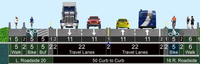
The bridge over Whitworth Drive is wide but also has some unique considerations for implementing the general cross-section described above. Below is a concept cross-section image that shows how the corridor’s proposed bicycle and pedestrian infrastructure is planned to be maintained across the bridge.
Image
Image of the concept cross-section of what US 395/Division Street could look like with protected bike lanes and sidewalks on the bridge over Whitworth Drive.
This cross-section consists of the following:
The west side (southbound) will keep the existing sidewalk and jersey barrier that separates it from the traffic lanes, as it is built into the bridge and must be kept in place. A minimum of a 5-foot bike lane plus up to 5 feet of buffer will be added atop the bridge deck (street level) on the other side of the jersey barrier and will be separated from the traffic lanes by a curb with tubular markers on top.
The east side will stripe a 6-foot pedestrian area, 2-foot buffer, and 5-foot bicycle lane atop the bridge deck (street level). These will be separated from the traffic lanes by a curb with tubular markers on top.
To add in the above infrastructure, traffic lanes will be narrowed to 11 feet and the center left turn lane will be removed. A 2-foot shoulder will be provided between the outside lanes and the curbs with tubular markers noted above. The centerline may be raised on a curb over the bridge.
Curb with tubular markers was selected across the bridge because jersey barrier could result in too much weight on the bridge and would require additional shoulder space per the WSDOT Design Manual, which would result in not enough space to fit all needed features on the bridge.
North of Hastings Road, the west side of the corridor (southbound) will keep the existing asphalt path that is set back from the roadway and widen it to 12 feet instead of adding sidewalk and separated bike lane. The east side (northbound) will have the sidewalk and separated bike lane described above.
The map below lays out the bicycle and pedestrian improvements as described above.
Image
Map showing where the selected walking and bicycling infrastructure improvements are expected to be along the US 395/Division Street project corridor, along with existing bike lanes, existing shared use paths, and planned local projects.
South of Hastings Road section
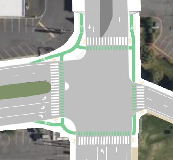
Not enough space within the existing right-of-way exists along the east side (northbound) of the project corridor south of Hastings Road between the two driveways of Fred Meyer shopping center to add the selected cross-section of separated bike lane and sidewalk while keeping the rest of the roadway as-is. To fit these needed improvements, WSDOT developed a baseline concept that fits within the existing right-of-way, as shown in the diagram below.
Aerial diagram showing what the baseline concept layout for US 395/Division Street south of Hastings Road may look like (example rendering, not exact to design).
This option, as shown in the concept above:
Keeps all three northbound general travel lanes but shifts them west by eliminating the center-left turn lane between the driveways.
Moves the start of the third northbound general travel lane from near the golf course to north of the southern Fred Meyer shopping center driveway.
Adds a concrete median curb between the directions of US 395/Division Street to prevent left turns in and out of the Fred Meyer shopping center on the east side and businesses on the west side because the center left turn lane is eliminated.
Adds the separated bike lane and sidewalk.
Maintains all turn lanes at the US 395/Division Street & Hastings Road signal.
Benefits of this option include:
Does not involve acquiring additional right-of-way to build the separated bike lane and sidewalk, saving funds that can be used towards other projects.
Shifts traffic, which contributes to managing speeds in a busy area.
Enhances safety by addressing a history of crashes involving turning vehicles at the driveways by eliminating the ability to turn left into and out of the shopping center and businesses on the west side, which simplifies decision-making and removes turning conflicts.
Tradeoffs for this option include:
Vehicles that want to turn left out of the shopping center onto US 395/Division Street will need to use driveways on Hastings Road, while those turning left out of the businesses on the west side will only be able to turn right and will need to find an alternative route.
Vehicles that want to turn left into the shopping center from southbound US 395/Division Street will need to turn left onto Hastings Road and turn right into the shopping center, while those turning left into the businesses west of US 395/Division Street will need to find an alternative route.
This design is set as the baseline strategy by WSDOT for this section because it uses existing space, reduces costs, and targets observed crash patterns at the driveways.
Crossing-Based Strategies
This section reviews proposed bicycle and pedestrian improvements for intersections and other crossings of the US 395/Division Street project corridor.
Pedestrian Hybrid Beacons (PHBs)
A Pedestrian Hybrid Beacon (PHB) – otherwise known as a HAWK signal – is a type of traffic signal designed specifically for pedestrians and bicyclists to cross busy wide streets with high speeds. It's particularly useful at locations where there is demand for pedestrians to cross, but a traditional traffic signal is not warranted or would be too disruptive.
A PHB improves the ability of pedestrians and bicyclists to cross by giving them a clear and protected time to cross while minimizing disruption to traffic flow when no one is crossing. When no one is crossing, the PHB stays off, and traffic flows normally. When someone presses the button to cross, the PHB goes through several phases:
Flashing yellow light: Alerts drivers that the light is about to change.
Solid yellow light: Tells drivers to prepare to stop – similar to the yellow phase of a traditional traffic signal.
Solid red light: Requires drivers to stop, allowing pedestrians to cross.
Flashing red light: After a few seconds, the light flashes red and is treated like a stop sign, allowing drivers to proceed if the crosswalk is clear.
WSDOT is planning to install PHBs at the following intersections, as traffic volumes and speeds are too high and the width of the roadway too great to place a crosswalk without a signal:
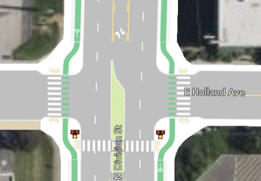
Holland Avenue Identified in the Spokane Regional Transportation Council’s DivisionConnects plan, this PHB will help connect homes with nearby businesses including grocery stores. It will also help crossings for Spokane Transit Authority’s (STA) planned bus rapid transit (BRT) stops on Division Street at this intersection while also improving access to existing bus stops nearby on US 2. The PHB will be added to the south leg, which will require eliminating northbound left turns at this intersection.
Image
Aerial diagram showing the conceptual layout of what the Holland Avenue PHB may look like (example rendering, not exact to design).
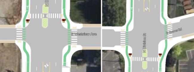
Westview Avenue Identified via the project’s community engagement, this PHB will help connect homes with several destinations that are popular to visit on foot, including a coffee shop, convenience store, and church. Which leg the PHB will be added to (north or south) is still being considered; however, WSDOT prefers the north leg. See below for additional information and a chance to provide input.
Graves Road The Spokane Regional Transportation Council’s DivisionConnects plan suggested this location for a traditional traffic signal to help with pedestrians crossing; however, the vehicular traffic here does not justify this level of investment. A PHB will help connect neighborhoods, Holmberg Park, and the US 2 corridor. Which leg the PHB will be added to (north or south) is still being considered; however, WSDOT prefers the south leg. See below for additional information and a chance to provide input.
Regina Avenue Identified via the project’s community engagement and analysis of historical crash data, this PHB will help connect neighborhoods, including a new apartment complex east of Division St., with several destinations, including a church, coffee shops, and the Fred Meyer shopping center. The PHB will be added to the north leg, which will require eliminating southbound and eastbound left turns at this intersection.
Image
Aerial diagram showing the conceptual layout of what the Regina Avenue PHB may look like (example rendering, not exact to design).
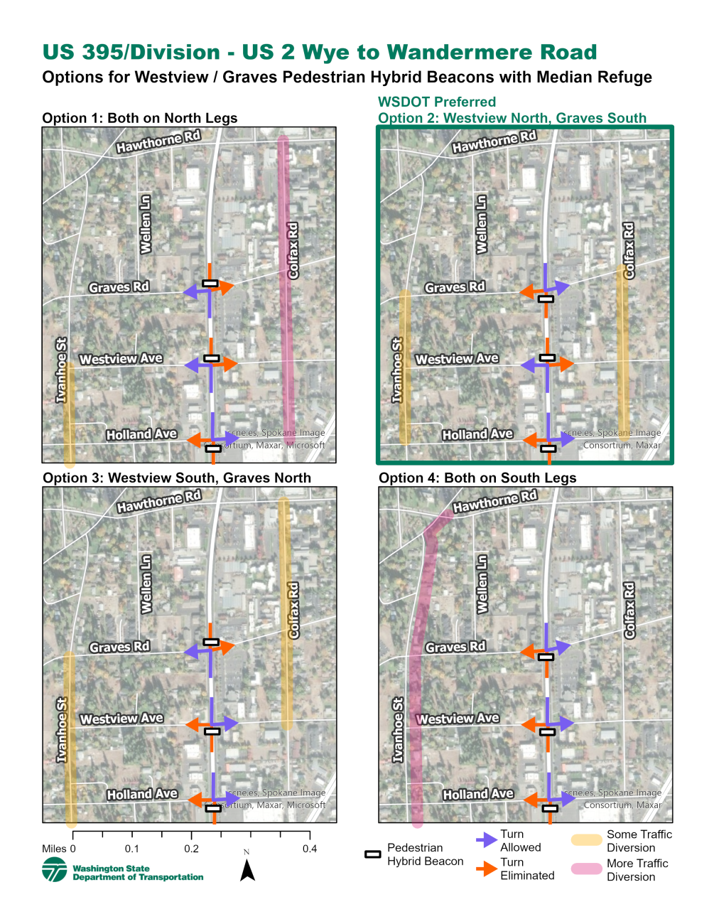
As noted above, which leg of the intersection the PHB will be located at both the Westview Avenue and Graves Road intersections is still being considered. The map below illustrates the combination of options between the two intersections and the impacts they have on left turns, access to adjacent properties, and traffic on alternative routes as a result of restricting some left turns. The analysis also took into account the PHB proposed at the Holland Avenue intersection, which will eliminate northbound left turns at that location.
Map showing the options for locating PHBs at Westview Avenue and Graves Road and how traffic could be impacted.
In summary, the options and their tradeoffs are:
Option 1: Both on North Legs This would require the elimination of southbound left turns at both intersections, as well as eastbound left turns from each side street. Adjacent properties would keep driveway access on US 395/Division Street, minimizing impacts. However, because no southbound lefts would be allowed between Hawthorne Road and Holland Avenue, traffic on Colfax Road to the east would likely increase to compensate.
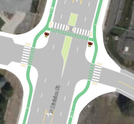
Option 2: On Westview North Leg, Graves South Leg – WSDOT Preferred This would eliminate northbound plus westbound left turns at the Graves Road intersection and southbound plus eastbound left turns at the Westview Avenue intersection. Combined with the PHB at Holland Avenue, this option would create an alternating effect of closing left turns. This would likely result in less traffic diversion on Ivanhoe Street and Colfax Road compared to other options. Adjacent properties would keep driveway access on US 395/Division Street, minimizing impacts. This option may also calm traffic on Graves Road to the west, which connects with Wall Street.
Image
Aerial diagrams of Option 2 showing the conceptual layout of what the Westview Avenue (left) and Graves Road (right) PHBs might look like (example renderings, not exact to design).
Option 3: Westview South Leg, Graves North Leg This would eliminate southbound plus eastbound left turns at the Graves Road intersection and northbound plus westbound left turns at the Westview Avenue intersection. Combined with the PHB at Holland Avenue and possible restrictions at Hoerner Avenue, no northbound left turns would be allowed between Country Homes Boulevard and Graves Road, likely leading to some additional traffic for longer stretches of Ivanhoe Street and Colfax Road. Adjacent properties would keep driveway access on US 395/Division Street, minimizing impacts. However, the property at the southwest corner of Westview Avenue does not have a driveway with US 395/Division and would not be directly accessible by northbound traffic, which would need to loop around via Graves Road.
Option 4: Both on South Legs This would require the elimination of northbound left turns at both intersections, as well as westbound left turns from each side street. Combined with the PHB at Holland Avenue and possible restrictions at Hoerner Avenue, no northbound left turns would be allowed between Country Homes Boulevard and Hawthorne Road, likely resulting in all impacted trips using Ivanhoe Street. Adjacent properties would keep driveway access on US 395/Division Street, minimizing impacts. However, the property at the southwest corner of Westview Avenue does not have a driveway with US 395/Division and would not be directly accessible by northbound traffic, which would need to use Ivanhoe Street to Westview Avenue to access. This is likely the most impactful option to circulation in the area.
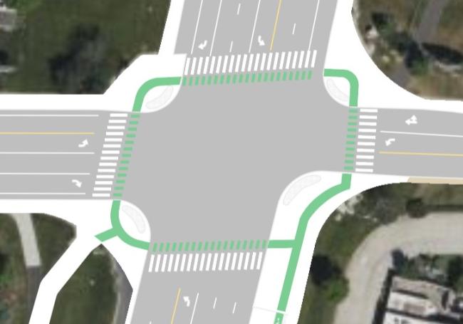
Protected Intersection
A protected intersection is designed to make intersections less stressful and reduce conflicts with motor vehicles for all road users, especially pedestrians and bicyclists. The main idea is to separate different users (cars, bikes, and pedestrians) and give everyone their own space to move through an intersection, which is often the most stressful part of a walking, biking, or rolling trip.
Key features include:
Separate and dedicated bicycle and pedestrian spaces: Both bicycles and pedestrians have their own spaces, including separate crossing spaces. For bicycles, this means left turns can be accomplished by traveling through the intersection and then across rather than having to share a left turn lane with motor vehicles. Bicycle space is often delineated with green pavement markings to further increase their visibility and communicate the separation of all modes.
Corner islands: These are small, raised areas at each corner of the intersection. They help protect cyclists by keeping them separate from cars turning right, and they make it easier for pedestrians to cross in a straight line. For this project, with bike lanes already being separated at sidewalk level, the corners of the protected intersections will be behind the curb, which will be expanded into the intersection to give more space to bicycles and pedestrians and slow vehicular traffic around the corners.
Set-back crossings: Crosswalks and bike crossings are set back from the main intersection. This means cars turning have more time and space to see and yield to people that are walking or biking.
WSDOT intends to construct protected intersections at the signalized intersections along the corridor. The following images and text describe what each protected intersection might look like.
Country Homes Boulevard
Image
Aerial diagram showing the conceptual layout of what the Country Homes Boulevard protected intersection may look like (example rendering, not exact to design).
Country Homes Boulevard has conventional bike lanes, but they do not reach/start at the intersection with US 395/Division Street. However, the protected intersection will be designed to allow the bike lanes to be extended in the future and connect with the protected features. In the meantime, bicyclists will either use the sidewalk or take the traffic lane to bridge the gap.
The existing raised medians on the north and west legs of this intersection will also be extended to form a median refuge for crossing bicyclists and pedestrians.
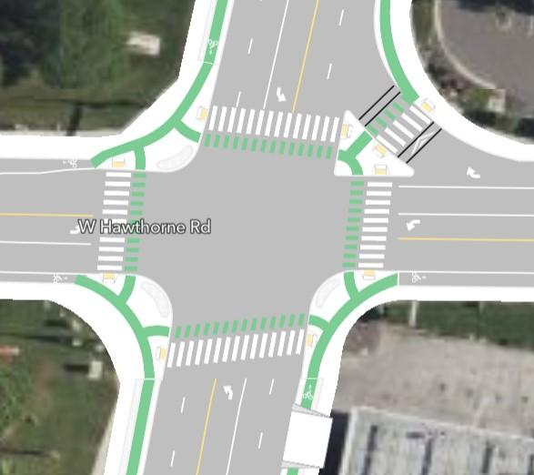
Hawthorne Road
Image
Aerial diagram showing the conceptual layout of what the Hawthorne Road protected intersection may look like (example rendering, not exact to design).
Hawthorne Road has conventional bike lanes that the protected intersection will connect with. This intersection also has a dedicated right turn lane known as a “slip” lane for those traveling westbound on Hawthorne Road and turning north onto US 395/Division Street. Protected intersections typically do not incorporate slip lanes, as these lanes are usually provided to allow right turning traffic to do so quickly, which creates a conflict with crossing bicycles and pedestrians. However, traffic volumes making this movement are high at this intersection and removing the slip lane would create significant congestion for westbound Hawthorne Road.
To provide a more comfortable crossing of the slip lane, the lane will be narrowed and made sharper to slow down traffic using it. Additionally, either the crosswalk across this lane will be raised (called a speed table) to slow down traffic or the lane will be signalized with a right turn arrow, stopping traffic at strategic times to allow bicycles and pedestrians to cross freely.
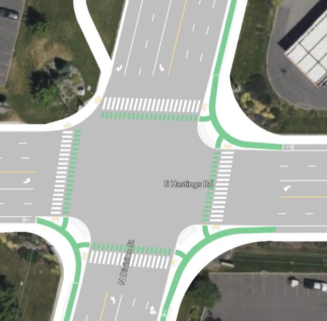
Hastings Road
Image
Aerial diagram showing the conceptual layout of what the Hastings Road protected intersection may look like (example rendering, not exact to design).
Hastings Road has conventional bike lanes that the protected intersection will connect with. Any future improvements to the bicycle lanes can also be designed to connect with the protected intersection.
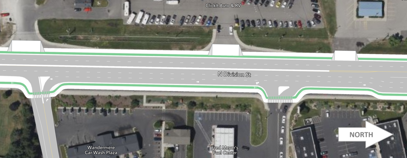
Farwell Road
Image
Aerial diagram showing the conceptual layout of what the Farwell Road protected intersection may look like (example rendering, not exact to design).
The Farwell Road protected intersection design will focus on providing an improved connection to the Children of the Sun trail and incorporating the widened shared use path that will be along the west side of US 395/Division Street between Hastings Road and Farwell Road, as no bike lanes currently exist on Farwell Road. However, future bicycle improvements on Farwell Road could be connected into the intersection. The protected intersection design will also add a crossing of the south leg of this intersection where there is not one currently.
Signal-Related Changes
How traffic signals are programmed and timed can be used to reduce conflicts between motor vehicles, pedestrians, and bicyclists and make pedestrians and bicyclists more visible. Specific strategies being considered at all signalized intersections include:
Leading Pedestrian Interval (LPI): Signal timing strategy giving pedestrians a head start at intersections before vehicles are allowed to move, making pedestrians more visible to turning vehicles.
Protected Left Turns: Allow left turns only when a green arrow is present and provide a red arrow to prevent turns when pedestrians and cyclists are crossing. When the crossing button has not been activated, left turns may be allowed with a flashing yellow arrow rather than a full green circle to reinforce to turning vehicles they must yield to oncoming vehicles and crossing pedestrians.
Accessible Pedestrian Signal (APS): At each corner of a signalized intersection, separate crossing button poles with audible directions are spaced apart to help pedestrians with visual impairments identify which direction is active to cross.
Additionally, “No Right Turns on Red” restrictions or right turn signalized arrows may be used in strategic locations to prohibit vehicles from making right turns at red lights to reduce conflicts with pedestrians and cyclists crossing the street.
Other Strategies
This section provides other strategies selected or being considered to provide a corridor that better supports active transportation users on the US 395/Division Street corridor between Country Homes Boulevard and Farwell Road.
Access Control
In addition to the section of the corridor south of Hastings Road, other locations are being considered for eliminating left turns in and out to reduce conflicts with passing bicycles, pedestrians, and vehicles. Locations include:
Hoerner Avenue (just north of Country Homes Boulevard)
Humboldt Drive (just north of Hawthorne Road)
Select driveways that are very close to signalized intersections
Hoerner Avenue is used by Spokane County Fire to travel north on US 395/Division Street during an emergency call. Any restrictions at this intersection will be designed to keep this route open for fire response vehicles.
Speed Management
Speed is a primary element of bicycle and pedestrian comfort and often a major contributor to serious crashes. The current speed limits for the corridor were set when the corridor was less developed, and adding improved bicycle and pedestrian infrastructure will further change the character of the corridor. Although the infrastructure proposed for this project is meant to achieve LTS 2 or better, managing speeds to be at or below the posted speed limit further contributes to achieving that level of comfort and reducing the severity of crashes. Strategies being considered for speed management include:
Chicanes: Curving of the roadway combined with raised curb and medians that shifts traffic in a manner so it must slow down. Chicanes are used at the entry points of roundabouts to slow entering traffic.
Removing tapers: Tapers are sloped widenings of the roadway at driveways that allow right turning vehicles to quickly exit the travel lane into the driveway, which creates a conflict with bicycles and pedestrians traveling across the driveway. Tapers will be removed along the corridor and replaced with a typical curbed corner or, for busy driveways, a dedicated right turn lane where space allows.
Tightening corner radius: Similar to tapers, wide sweeping corners allows for vehicles to turn right quickly at driveways and intersections, which creates a conflict with crossing bicycles and pedestrians. Corners along the project corridor will be analyzed to potentially reduce their radius to slow entering traffic. Types of vehicles will be taken into consideration at each location using special software to models large vehicle turning patterns. Curb that can be mounted by such large vehicles will also be considered in design.
Raised driveways: Creating a steeper slope at the entry of driveways, and placing the crossing bike lane and sidewalk at the peak of the slope, forces entering and existing vehicles to do so slower. Since this requires the curving of bike lanes from along the street to behind the driveway, it also can slow crossing bicycles, enabling both vehicles and bicycles to better see each other.
These strategies may allow for the reduction of the speed limit in the future. Independent of this project, lowering the 50 mph speed limit north of Hawthorne Road to 45 mph is being considered. Additional speed limit reductions will be explored after this project is constructed.
Visibility and Awareness Improvements
Other improvements that will be incorporated into the project to improve the visibility of bicycles and pedestrians include:
Pavement markings including green pavement markings for bicycles at intersections, major driveways, and potentially busier more densely developed sections of the corridor. Special materials and application techniques will be used to reduce maintenance of these markings and keep them visible longer. Crosswalks will also be replaced using these types of materials.
Signing to draw attention to drivers that there may be crossing bicycles and/or pedestrians.
Lighting, particularly at new/improved crossings, will be added/improved. Specific locations will be identified in the design phase.
These improvements also bring greater awareness to vehicles that bicycles and pedestrians may be present.
Complete Streets General FAQs
Q: What are Complete Streets?
A: This new design approach serves all users, regardless of age, ability, or mode of travel. It focuses on planning, designing, building, operating, and maintaining a transportation system that provides comfortable and convenient access to destinations for everyone. Accessibility is especially important for people who walk, bike, or roll, with "rolling" referring to mobility by wheelchair or other assistive devices. This approach aims to create a transportation system that works for everyone, strengthens communities, expands options for non-drivers, and makes travel more reliable. It also includes ensuring ADA-compliant sidewalks and crosswalks, especially at high-traffic intersections. Safety and community collaboration are the most important aspects of this approach. For more information visit WSDOT’s Complete Streets site.
Q: Why is WSDOT using funds towards improvements for bicycles and pedestrians?
A: In 2022, the Washington State Legislature passed Move Ahead Washington, requiring WSDOT to incorporate Complete Streets principles into transportation projects in population centers with an estimated budget over $500,000 and starting design on or after July 1, 2022. WSDOT adopted these principles to enhance access for all users, including pedestrians, bicyclists, and public transportation users, in projects constructed on state highways consistent with RCW 47.04.035. This approach aims to improve accessibility not only for those who choose to walk and bike for leisure and recreation but for those who rely on these modes as their primary means of transportation.
Q: Why is WSDOT spending money on bicycle and pedestrian infrastructure if I don’t see people walking or biking?
A:A: By law, it is WSDOT’s responsibility to invest in bicycle and pedestrian infrastructure to create more accessible and comfortable environments for all mode users. A lack of people currently walking and biking can often be traced to the existing environment feeling uncomfortable and exposed. When more dedicated and comfortable options are available, more people are likely to walk or bike. Studies show that providing these facilities encourages more people to choose active transportation, reducing traffic congestion, improving public health, and enhancing community well-being.
Q: Can bicycle infrastructure and routing be added to nearby local streets instead of the state highway corridor?
A: State highway corridors often provide direct, efficient routes to key destinations like businesses, schools, and transit hubs. Residential streets may not offer the same connectivity. In addition, state law does not currently allow WSDOT to develop on locally owned roads due to constraints related to right-of-way and ownership. Locally owned roads fall under the jurisdiction and control of the respective local government, which holds the authority over their maintenance, development, and management.
Q: Bicycle infrastructure already exists on nearby local streets or is planned. Can this satisfy WSDOT’s Complete Streets requirement?
A: In very limited circumstances, existing bicycle infrastructure can count towards WSDOT’s satisfaction of the Complete Streets requirement. However, this must be determined on a case-by-case basis and the local infrastructure must meet the same requirements WSDOT is held to. Planned improvements must be funded and scheduled for construction to be considered and must meet the same conditions as existing infrastructure.
Q: Will any car lanes be removed to make room for bicycle or pedestrian improvements?
A: In some cases, car lanes may be reconfigured or reduced to accommodate other modes of transportation, especially if the goal is to enhance safety and improve traffic flow for all users. However, each project location is unique requiring a careful study and alternative solutions are considered.
Important Bike Lane Terminologies
Conventional Bike Lane: Also referred to as a “traditional” bike lane or simply a “bike lane”, this type consists of a designated lane on the roadway exclusively for cyclists, separating bicycles from vehicles with a painted line accompanied by symbols and signage. Conventional bike lanes provide increased comfort for cyclists on lower-traveled, lower-speed roadways but become less comfortable on busier and higher-speed roadways.
Buffered Bike Lane: A bike lane that includes a painted buffer zone between the bike lane and motor vehicle lanes. The buffer adds extra space, increasing comfort by providing additional separation between cyclists and motor vehicles.
Separated Bike Lanes (Protected Bike Lanes): Bike lanes that are physically separated from motor vehicle traffic by barriers such as plastic tube markers, curbs, planters, or even parked cars. These lanes offer a higher level of comfort for cyclists by providing a physical barrier between them and motorized traffic.
Shared Use Path: A paved pathway designed for both pedestrians and cyclists, usually wider than a standard sidewalk (10 feet at minimum). Shared use paths are often found in parks, along rivers, or parallel to roadways, providing a comfortable off-street option for non-motorized travel completely separated from motor vehicles.
Project-Specific FAQs
Q: What are WSDOT’s plans for maintaining a snow-free bike lane?
A: WSDOT as an agency is researching how to address snow removal and general maintenance for separated bike lanes and other bicycle/pedestrian infrastructure, including what equipment would be best for different situations. Currently, WSDOT Eastern Region lacks the appropriate equipment and faces significant budget challenges for staff to clear bike lanes and shared use paths that are separated from roadway. However, the sidewalk-level separated bike lanes were selected in part because WSDOT maintenance staff noted this facility would be easier to maintain, particularly as additional equipment is obtained. In short, WSDOT cannot guarantee to keep the bike lanes free of snow once the facility is constructed; however, is investigating options to try and get to that point in the future.
Q: Has a hardened barrier, like a jersey barrier, been considered to separate vehicle traffic from the bike lane?
A: Yes, WSDOT considered various barrier options including the jersey barrier and the emerging Toronto barrier. However, barriers create maintenance challenges, especially when they separate the roadway and pedestrian/bicycle facilities. For the roadway, it is difficult to clear snow over barriers and the space available leaves no room for snow to store around the barrier, while also making it more difficult for maintenance staff to enter the bike lanes and sidewalks they protect to clear them from snow and debris that accumulates behind the barrier. Additionally, barriers require more space, particularly at higher speeds, which is not available for much of the corridor. And the bridge over Whitworth Drive may not have enough load capacity to add barriers.
Q: What are your strategies to coordinate with state and local law enforcement to enforce speed limits along the corridor, especially on some portions that may have speed reductions from the present speeds of 50 mph and 45 mph?
A: The team is engaging with state and local law enforcement as part of this project. Our agency coordination group includes law enforcement representatives and will continue collaborating as the project progresses. Specific strategies being explored to promote the adherence to reduce speeds include narrowing lane widths, pedestrian hybrid beacons (PHBs), and raised medians in strategic locations such as for median refuges at crossings. Additional strategies to influence speeds are also being investigated.
Q: Can more space be provided between the roadway and sidewalk-level bike lane?
A: Space within WSDOT’s right-of-way is limited for much of the corridor, with the current design utilizing nearly all available space once factoring in drainage and slope constraints. However, the project team is reviewing the corridor to see if more space can be provided in select areas.
Other questions
Q: When will the North Spokane Corridor be finished?
A: This is a major project that has been in development for many years, with construction currently active. To date, 7 miles have been completed, with only 3.5 miles remaining. The expected project timeline is to be completed in the early 2030's. For more detailed timeline information and the latest updates, visit the North Spokane Corridor project webpage.
Shea Suski Principal Multimodal Planner – Complete Streets Lead 509-324-6135 shea.suski@wsdot.wa.gov